
Photo Credit: Nancy Wedwick teaches a student group about agriculture conservation on a ridge overlooking Coon Valley. During the 1930s, Coon Valley residents collaborated with state and federal partners to significantly reduce flooding and erosion in this watershed as part of the nation’s first watershed conservation project. Photo: Sydney Widell
With historic dam decommissioning looming, commitments to watershed conservation increasingly critical for flood mitigation
By Nancy Wedwick – President, Coon Creek Community Watershed Council
Ninety years ago, Southwestern Wisconsin’s Coon Creek Watershed rose to the seemingly impossible challenge of reversing catastrophic soil erosion and flooding, problems so severe they threatened to destroy farming as a way of life. Farmers, agriculturalists, federal employees, and university researchers came together in 1933 to implement widescale conservation practices in what would become the nation’s first ever watershed demonstration project, and a model for positive change across the nation.
Today, our Coon Creek Watershed is again faced with a seemingly impossible challenge, as the Natural Resources Conservation Service is recommending the notching of 22 of the 23 PL-566 earthen flood control dams in this watershed and in the adjacent West Fork Kickapoo watershed, dams that we have been told, for 70 years, have been protecting us from our increasingly worse floods. We have the opportunity, again, to come together to consider the pivotal role that conservation-based land management must play in helping us live together through these worsening floods. Though I have lived in this watershed most of my life and call this place home, all of this I have learned since becoming a founding member of the Coon Creek Community Watershed Council, Inc.
This fall will mark the 91st anniversary of the Nation’s first large-scale conservation demonstration, the Coon Creek Watershed Project, that changed the face of the earth here in Coon Creek and then well beyond, leading to a nationwide effort to stop soil erosion during the Dust Bowl Years.
Some 90 years ago, this Driftless Area suffered from intense soil erosion and flooding as the result of agricultural practices implemented by my ancestors and others from western and northern Europe, practices that worked in Europe but did not translate here because the climate was different. As people connected the erosion and flooding with land use management, entrepreneurial farmers began to experiment with conservation-based land use practices.
At the same time, the federal government realized that a national catastrophe of historic proportions was underway and so, through a series of events, the federal government in the form of the Soil Erosion Service (later the Soil Conservation Service, and today the Natural Resources Conservation Service, NRCS), the Civilian Conservation Corps, the University of Wisconsin-Madison, and our local farmers, agriculturalists and those who lived in this area collaborated to create and implement the famous and successful Coon Creek Watershed Project.
In the late 1950’s and early 1960’s, the Soil Conservation Service again came to this area to work with our communities to try to create more protection from flooding by building dams, the PL-566 dams.
To build the dams, 22 of them in Vernon County of 82 across the state, Public Law 566 required community participation, and 50 percent of the landowners upstream of the proposed dam sites to engage in conservation-based land management practices. It was through the requirement of community participation that the first Coon Creek Watershed local organization was born, and the dams were constructed. And, crucially, these land management changes—and the effects they had on soil infiltration—have been shown to account for many of the flood control benefits attributed to the dams.
In concert with these conservation measures, for nearly 70 years, the dams seemed to work even beyond their expected 50-year life span to support flood protection. The first time I walked onto one of these dams, better than 30 years ago, I did not know what to make of the sloped earthen structure stretching across the valley and offering sweeping views on either side. It was a dam I was told, and this made no sense to me because there was no water in sight.
Then, on August 27, 2018, incredibly heavy rains began and five of the PL-566 dams in the Coon Creek and West Fork Kickapoo watersheds breached or overtopped, an unprecedented event unleashing torrents of water rushing through the valleys destroying homes, farms and businesses in its path. A community came together and a second watershed organization, the Coon Creek Community Watershed Council, was formed. It was in the aftermath of this destruction that I came to understand so much more about these dams.
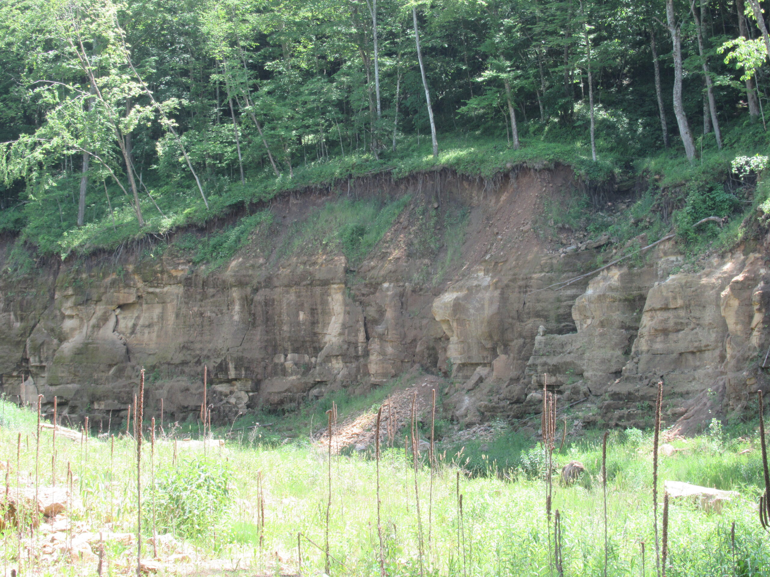
The NRCS had to investigate to determine what happened. In late 2023, this investigation and legally mandated report, known as the PLAN-EIS, or Environmental Impact Statement, concluded that the dams had aged out, were compromised due to their connection to fractured bedrock, and unsafe. This makes sense, especially given the devastation wrought by the 2018 storm, and storms prior to and after as the result of rain events with increasing intensity, frequency and duration.
This spring, NRCS recommended the dams be decommissioned by cutting a large notch in the dams to pass water up to the 100-year flood event, a flood that has the likelihood of occurring once in every 100 years, though that frequency is no longer accurate. The notched dams will be sloped and reinforced with rock. Material excavated from these decommissioned dams will be redistributed across valley bottoms, where it is expected to be mobilized in future storms and eventually carried downstream. The terms of the federal decommissioning recommendation also suggest that counties relinquish the easements to dams back to their owners, who are mostly private landowners.
This decision will have huge consequences in the coming storms. The decommissioning of all 14 of these structures in the Coon Creek Watershed at once will be the first instance of watershed-wide flood protection abandonment in the United States.
La Crosse, Monroe and Vernon counties are now being asked to accept this recommendation from NRCS, and they feel pressure to do so. The risk of breach is real, and the federal government is offering to pay 100 percent of the cost of decommissioning if the counties follow their recommendation. I have stood upon two of the dams that breached, and the devastation is visible today. The danger is clear. The recommendation to decommission is not.
The PLAN-EIS report explored several alternatives to decommissioning, one being collaborating with landowners in this area to increase conservation land use practices such as cover crops, perennials, grazing, to mitigate the effects of flooding. Another alternative involved collaborating with landowners to install small ponds to mitigate flooding.
These alternatives were rejected by NRCS. The reason given for rejecting the alternatives is that NRCS did not think it would be feasible for landowners to voluntarily implement and increase conservation land use practices and small ponds.
This reason runs contrary to the storied history of volunteer conservation efforts by landowners in the Coon Creek Watershed and this reason does not address the need to mitigate the effects of flooding. History has shown that watershed residents have voluntarily made dramatic changes before. Many are making changes now and I know more will.
The current recommendation leaves many questions. Who will be responsible for the remaining dam structures? Who takes care of them? What happens when a rain event occurs beyond the 100-year level? What happens when the earthen material from remaining notched structures is washed downstream in rushing flood waters?
Also, I wonder: what if, as has been the history of this watershed and the federal government and the University of Wisconsin-Madison and our watershed community, we work together to improve conservation efforts and mitigate the effects of the dam decommissioning through a coordinated, collaborative, and funded pilot project?
There are almost 12,000 PL-566 dams across the nation, all of which will begin to face the same decisions we are facing here now. With our 14 dams in the Coon Creek Watershed, and 9 dams in the West Fork Kickapoo Watershed, the decommissioning that is about to happen here is unprecedented and will once again set the stage for what happens across the country.
This event is historic. How we meet the challenge is once again being watched by the world and will be written into the history of conservation efforts worldwide.
Fortunately, we have the depth of community expertise, community interest, and community participation at the ready to take this challenge. We also have our friends at UW-Madison, who are already engaging in research the community has requested, and who are actively seeking funding to support the work ahead of us. Experts in dam decommissioning and dam removal at the national and regional level are aware of the current situation here, are deeply concerned, and stand ready to help.
We just need the final piece, our federal government to join us as partners in this growing movement, as it did 90 years ago in this watershed. This is about more than funding the replacement of the dams’ flood control capacity through a panoply of practices. Instead, we are calling for coordinated land management transformation to address some of the root causes of flooding, while also enhancing soil and water health, creating economic opportunities and advancing community resilience.
Given this unprecedented and historic decommissioning proposal, we need a coordinated, collaborative, funded watershed-wide project to decommission or fully remove the dams and implement land use practices with minimal financial risk to the landowners, transforming the landscape which will result in flood mitigation and increased resilience.
Nancy Wedwick is a fifth generation Coon Creek Watershed resident, and President of the Coon Creek Community Watershed Council (CCCWC). She can be reached at nancywedwick@cooncreekwatersed.org or at 608.386.9086. Find CCCWC online at cooncreekwatershed.org